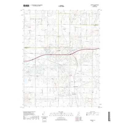
2019 Map of Lynnville
USGS Topo · Published 2019About this map
Lynnville serves as the central hub of this Southern Indiana landscape, where the intersection of W State Rd 68 and the Interstate corridor shapes the modern geography. The terrain is defined by a series of distinct rises, including Ringham Hill, Dyson Knob, and Big Ditney Hill, which overlook the winding paths of Smith Fork and Big Cr. For those tracing local heritage, the map is punctuated by numerous small cemeteries such as Mount Olive Cem, Massey Cem, and Morrison Cem, which mark the sites of early rural communities. Settlements like Stanley and Graham Valley appear as dispersed residential clusters along the county road network, while the north is bordered by the Hemmer Woods Nature Preserve Trail. This survey captures the region as it transitioned into the twenty-first century, balancing interstate accessibility with the preservation of family burial grounds and traditional land names.
Find a feature on this map
66 named features on this map. Tap any name to fly to it.
Don’t see what you’re looking for? This feature index may not catch every label — zoom into the map to look around manually.
Map Details
Editions of this 2019 Lynnville Map
This is the sole edition of this map. No revisions or reprints were ever made.
Other maps of this area

1900 · De Gonia Springs
USGS Topo · 1:62,500

1902 · Ditney
USGS Topo · 1:125,000

1902 · Degonia Springs
USGS Topo · 1:62,500

1902 · Boonville
USGS Topo · 1:62,500

1903 · Velpen
USGS Topo · 1:62,500

1903 · Petersburg
USGS Topo · 1:62,500

1956 · Vincennes
USGS Topo · 1:250,000

1957 · Vincennes
USGS Topo · 1:250,000

1958 · Vincennes
USGS Topo · 1:250,000
1960 · De Gonia Springs
USGS Topo · 1:24,000