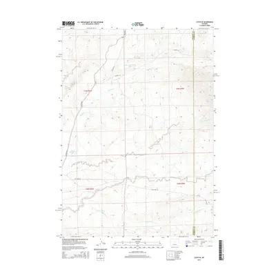
2015 Map of Lysite SE
USGS Topo · Published 2015About this map
Badwater Cr and its numerous tributaries dominate this high-desert terrain along the boundary of Fremont and Natrona counties. The landscape is defined by its complex drainage network, where the South Fork Badwater Cr and S Fork Badwater Cr converge to feed into more significant water bodies. Man-made water management is evident at Snyder Creek Reservoir and Okie Reservoir, which provide vital resources in an arid region characterized by ephemeral washes like Sand Cr and S Fork Sand Cr. The road network is sparse, consisting largely of primitive routes such as Lost Cabin Rd and Nowood Rd, which follow the natural contours of the drainages. This cartography illustrates a modern-era view of the Wyoming ranching and rangeland environment, where topography and water sources dictate the placement of transportation lines.
Find a feature on this map
20 named features on this map. Tap any name to fly to it.
Don’t see what you’re looking for? This feature index may not catch every label — zoom into the map to look around manually.
Map Details
Editions of this 2015 Lysite SE Map
This is the sole edition of this map. No revisions or reprints were ever made.
Other maps of this area

1952 · Cottonwood Pass
USGS Topo · 1:24,000

1952 · Moneta
USGS Topo · 1:24,000

1952 · Badwater
USGS Topo · 1:24,000

1952 · Lysite
USGS Topo · 1:24,000

1952 · Madden
USGS Topo · 1:24,000

1952 · Arminto NW
USGS Topo · 1:24,000

1952 · Lysite SE
USGS Topo · 1:24,000

1952 · Sioux Pass
USGS Topo · 1:24,000

1952 · Arapahoe Butte
USGS Topo · 1:24,000

1955 · Arminto
USGS Topo · 1:250,000