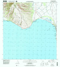
1996 Map of Maalaea
USGS Topo · Published 1999About this map
Maalaea serves as the central hub of this coastal survey, where the Maalaea Small Boat Harbor and Maalaea Haycraft Beach Park meet the waters of Maalaea Bay. The map captures a transition between the steep, dramatic elevations of the West Maui Forest Reserve—marked by prominent features like Pohakea Ridge and Puu Luau—and the low-lying wetlands of Kealia Pond. To the east, the burgeoning community of Kihei begins to take shape, showing early residential patterns near the Waiohuli Keokea Homesteads. The infrastructure of the era is clearly defined by the Honoapiilani Highway winding along the coast past McGregor Point, providing a record of mid-to-late 20th-century transportation and land use on Maui’s southern shores.
Find a feature on this map
39 named features on this map. Tap any name to fly to it.
Don’t see what you’re looking for? This feature index may not catch every label — zoom into the map to look around manually.
Map Details
Editions of this 1996 Maalaea Map
This is the sole edition of this map. No revisions or reprints were ever made.
Other maps of this area

1929 · Kahoolawe
USGS Topo · 1:62,500

1954 · Maui
USGS Topo · 1:250,000

1954 · Maalaea
USGS Topo · 1:24,000

1954 · Paia
USGS Topo · 1:24,000

1954 · Puu O Kali
USGS Topo · 1:24,000

1954 · Makena
USGS Topo · 1:24,000

1955 · Olowalu
USGS Topo · 1:24,000

1955 · Wailuku
USGS Topo · 1:24,000

1956 · Lahaina
USGS Topo · 1:24,000

1966 · Maui
USGS Topo · 1:250,000