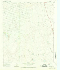
1966 Map of Mabee Ranch
USGS Topo · Published 1971About this map
Industrial expansion and water infrastructure define the Permian Basin landscape in this mid-1960s study of the Andrews Co Martin Co line. The map is dominated by the extensive Mabee Oil Field, a dense network of resource extraction marked by numerous Oil Wells, access roads, and a central Pumping Station. This oil-rich environment is punctuated by a modern Aqueduct and pipeline system cutting across the desert floor, alongside the eponymous Mabee Ranch headquarters. Local relief is minimal, save for the distinct landform at Dunn and various excavations like the Gravel Pit. The map captures a moment when traditional ranching lived side-by-side with the heavy infrastructure of the Texas energy sector, linked to the outside world by Texas 349 and Texas 176.
Find a feature on this map
11 named features on this map. Tap any name to fly to it.
Don’t see what you’re looking for? This feature index may not catch every label — zoom into the map to look around manually.
Map Details
Editions of this 1966 Mabee Ranch Map
2 editions found
Other maps of this area

1954 · Hobbs
USGS Topo · 1:250,000

1958 · Hobbs
USGS Topo · 1:250,000

1965 · Northeast Midland
USGS Topo · 1:24,000

1966 · Mabee Ranch
USGS Topo · 1:24,000

1966 · Flynt Ranch
USGS Topo · 1:24,000

1966 · Bird Ranch
USGS Topo · 1:24,000

1966 · North Curtis Ranch
USGS Topo · 1:24,000

1966 · Northwest Midland
USGS Topo · 1:24,000

1968 · Baird Lake
USGS Topo · 1:24,000
1968 · Hackberry Lake
USGS Topo · 1:24,000