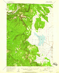
1954 Map of Macdoel
USGS Topo · Published 1960About this map
The Klamath River flows through the rugged northern landscape of the Klamath National Forest in this 1954 survey, where the high timberlands of Ball Mtn and McGavin Peak meet the agricultural flats of the Butte Valley. The settlement of Macdoel serves as the local hub along the Southern Pacific railroad line, supported by nearby cattle operations like the Meiss Ranch and Martin Dairy.
Find a feature on this map
76 named features on this map. Tap any name to fly to it.
Don’t see what you’re looking for? This feature index may not catch every label — zoom into the map to look around manually.
Map Details
Editions of this 1954 Macdoel Map
3 editions found

Other maps of this area

1886 · Modoc Lava Bed
USGS Topo · 1:250,000

1886 · Shasta
USGS Topo · 1:250,000

1889 · Klamath
USGS Topo · 1:250,000

1891 · Ashland
USGS Topo · 1:250,000

1892 · Modoc Lava-Bed
USGS Topo · 1:250,000

1893 · Ashland
USGS Topo · 1:250,000

1894 · Klamath
USGS Topo · 1:250,000

1894 · Shasta
USGS Topo · 1:250,000

1897 · Ashland
USGS Topo · 1:250,000

1934 · Macdoel
USGS Topo · 1:96,000