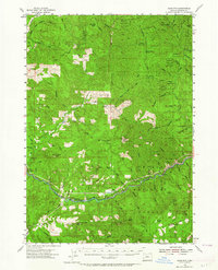
1955 Map of Mace Mtn
USGS Topo · Published 1964About this map
The North Fork Umpqua River carves through the heart of this mid-century wilderness, following a course roughly paralleled by the North Umpqua Highway. This rugged terrain within the Umpqua National Forest is characterized by remote outposts and infrastructure supporting forest management and early recreation. Landmarks such as the Rock Cr Guard Sta and the Gaging Sta reflect the administrative presence in the backcountry, while several shelters like the Canton Shelter and Trapper Shelter provided refuge for those navigating the high ridges and deep drainages.
Find a feature on this map
84 named features on this map. Tap any name to fly to it.
Don’t see what you’re looking for? This feature index may not catch every label — zoom into the map to look around manually.
Map Details
Editions of this 1955 Mace Mtn Map
2 editions found
Other maps of this area

1897 · Roseburg
USGS Topo · 1:125,000

1900 · Roseburg
USGS Topo · 1:125,000

1935 · Lowell
USGS Topo · 1:96,000

1942 · Lowell
USGS Topo · 1:125,000

1954 · Dixonville
USGS Topo · 1:62,500

1954 · Anlauf
USGS Topo · 1:62,500

1954 · Glide
USGS Topo · 1:62,500

1955 · Quartz Mtn
USGS Topo · 1:62,500

1955 · Red Butte
USGS Topo · 1:62,500

1955 · Mace Mtn
USGS Topo · 1:62,500