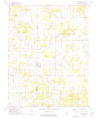
1974 Map of Macedonia
USGS Topo · Published 1977About this map
Franklin and Hamilton counties converge in this southern Illinois landscape, where the rural settlements of Macedonia and Akin serve as local hubs. The terrain is defined by the Middle Fork Muddy River, which meanders through a network of small tributaries including Goose Creek and Sullivan Branch. This 1970s survey illustrates a region where agriculture and resource extraction coexist, with the Dale Oil Field and various pipelines marking the southern reaches near Greasy Creek. Genealogy researchers will find an exceptional density of family and community burial grounds, from the Atchisson Cem and Walnut Grove Cem to the Gilgal Cem. These sites, often paired with country churches like Mt Nebo Ch and Pleasant Grove Ch, highlight the enduring social geography of the Knight Prairie and Flannigan townships during this era.
Find a feature on this map
38 named features on this map. Tap any name to fly to it.
Don’t see what you’re looking for? This feature index may not catch every label — zoom into the map to look around manually.
Map Details
Editions of this 1974 Macedonia Map
This is the sole edition of this map. No revisions or reprints were ever made.
Other maps of this area

1908 · Galatia
USGS Topo · 1:62,500

1909 · West Frankfort
USGS Topo · 1:62,500

1938 · Galatia
USGS Topo · 1:62,500

1939 · Ina
USGS Topo · 1:62,500

1941 · West Frankfort
USGS Topo · 1:62,500

1942 · McLeansboro
USGS Topo · 1:62,500

1943 · Ina
USGS Topo · 1:62,500

1945 · McLeansboro
USGS Topo · 1:62,500

1949 · Paducah
USGS Topo · 1:250,000

1950 · Paducah
USGS Topo · 1:250,000