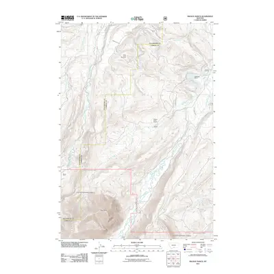
2011 Map of Mackay Ranch
USGS Topo · Published 2011About this map
Roscoe Cemetery sits near the northeastern corner of this Carbon County landscape, overlooking a network of agricultural waterworks that sustain the local ranching economy. The complex irrigation system is evidenced by numerous gravity-fed features including the Miller Ditch, Oakley-Parker Ditch, and the Antelope Basin Ditch. These man-made channels draw from the perennial flows of East Rosebud Creek and West Rosebud Creek, which dominate the drainage pattern of the region. The map illustrates a sparse, ranch-oriented settlement pattern centered around family-named operations like the Mackay Ranch, which includes the private Mackay Ranch Airport, and the T O Bar Ranch to the south. Distinctive landmarks such as the curiously named Stick-in-the Mud Dam and the prominence of Black Butte provide clear orientation points in this high-plains environment where water management and cattle remain the primary drivers of land use.
Find a feature on this map
31 named features on this map. Tap any name to fly to it.
Don’t see what you’re looking for? This feature index may not catch every label — zoom into the map to look around manually.
Map Details
Editions of this 2011 Mackay Ranch Map
This is the sole edition of this map. No revisions or reprints were ever made.
Other maps of this area

1898 · Granite Mountain District
USGS Topo · 1:125,000

1932 · Red Lodge No 2
USGS Topo · 1:48,000

1932 · Nye No 1
USGS Topo · 1:48,000

1954 · Billings
USGS Topo · 1:250,000
1956 · Emerald Lake
USGS Topo · 1:24,000
1956 · Fishtail
USGS Topo · 1:24,000

1956 · Roscoe
USGS Topo · 1:24,000

1956 · Alpine
USGS Topo · 1:62,500

1956 · Mackay Ranch
USGS Topo · 1:24,000

1956 · Roscoe NW
USGS Topo · 1:24,000