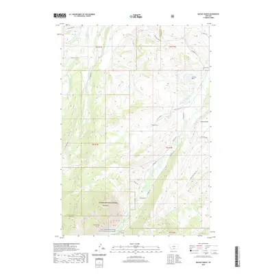
2020 Map of Mackay Ranch
USGS Topo · Published 2020About this map
The East Rosebud Creek Wild and Scenic River and its surrounding watershed define this high-country landscape along the border of Stillwater and Carbon Counties. At the northern edge of the Custer National Forest, the terrain transitions from the heights of Black Butte down toward the irrigation networks of the foothills. This 2020 survey documents a complex system of historical water rights, featuring long-established channels like the Oakley-Parker Ditch, Miller Ditch, and Peabody Ditch which support local ranching. The presence of Mackay Ranch and the Roscoe Cem near the eastern boundary reflects the area's long-standing agricultural and community identity. Significant topographic features like Antelope Basin and Coleman Bench provide context for the local road network, including W Rosebud Rd and the Getaway Trl, which navigate the steep drainage systems of West Rosebud Creek and Morris Cr.
Find a feature on this map
47 named features on this map. Tap any name to fly to it.
Don’t see what you’re looking for? This feature index may not catch every label — zoom into the map to look around manually.
Map Details
Editions of this 2020 Mackay Ranch Map
This is the sole edition of this map. No revisions or reprints were ever made.
Other maps of this area

1898 · Granite Mountain District
USGS Topo · 1:125,000

1932 · Red Lodge No 2
USGS Topo · 1:48,000

1932 · Nye No 1
USGS Topo · 1:48,000

1954 · Billings
USGS Topo · 1:250,000
1956 · Emerald Lake
USGS Topo · 1:24,000
1956 · Fishtail
USGS Topo · 1:24,000

1956 · Roscoe
USGS Topo · 1:24,000

1956 · Alpine
USGS Topo · 1:62,500

1956 · Mackay Ranch
USGS Topo · 1:24,000

1956 · Roscoe NW
USGS Topo · 1:24,000