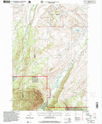
1996 Map of Mackay Ranch
USGS Topo · Published 1999About this map
High-altitude ranching and complex irrigation networks define this section of the Beartooth foothills during the late 1990s. The landscape is characterized by the descent of West Rosebud Creek and East Rosebud Creek from the Absaroka Beartooth Wilderness and Custer National Forest into the lower valleys. This transition from wilderness to agriculture is marked by an extensive system of water rights, evidenced by the Espeland Ostrum Ditch, John George Ditch, and Peabody Ditch which lace across the Coleman Bench. The presence of established operations like the Mackay Ranch (Lazy E K) and T O Bar Ranch, alongside the Roscoe Cem, provides a detailed look at the social and economic fabric of this mountain-front community. Notable landmarks such as Black Butte and the Antelope Basin serve as essential orientation points for the surrounding terrain.
Find a feature on this map
35 named features on this map. Tap any name to fly to it.
Don’t see what you’re looking for? This feature index may not catch every label — zoom into the map to look around manually.
Map Details
Editions of this 1996 Mackay Ranch Map
This is the sole edition of this map. No revisions or reprints were ever made.
Other maps of this area

1898 · Granite Mountain District
USGS Topo · 1:125,000

1932 · Red Lodge No 2
USGS Topo · 1:48,000

1932 · Nye No 1
USGS Topo · 1:48,000

1954 · Billings
USGS Topo · 1:250,000
1956 · Emerald Lake
USGS Topo · 1:24,000
1956 · Fishtail
USGS Topo · 1:24,000

1956 · Roscoe
USGS Topo · 1:24,000

1956 · Alpine
USGS Topo · 1:62,500

1956 · Mackay Ranch
USGS Topo · 1:24,000

1956 · Roscoe NW
USGS Topo · 1:24,000