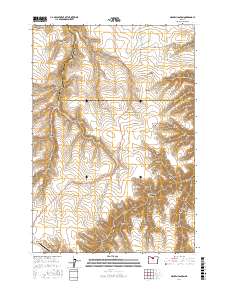
2017 Map of Macken Canyon
USGS Topo · Published 2017About this map
Buck Hollow Cr and Spring Cr carve through the high plateau country of north-central Oregon, defining a landscape of deep canyons and seasonal drainages. This area, straddling the border of Wasco and Sherman Counties, is characterized by its high-elevation topography and sparse water sources, which were critical for early ranching operations. The presence of Kelsey Spring and Taylor Springs suggests the vital importance of natural water points in this arid environment. The terrain is marked by numerous named landforms with colorful local designations like Wampus Cat Canyon, Moonshine Canyon, and Rock Corral Canyon, reflecting the regional heritage of homesteading and cattle ranging. Human activity is concentrated around the Shaniko Ranch Airport and the complex network of hollows such as Chapman Hollow and Little Thorn Hollow, providing a clear view of the rural infrastructure at the edge of the high desert.
Find a feature on this map
29 named features on this map. Tap any name to fly to it.
Don’t see what you’re looking for? This feature index may not catch every label — zoom into the map to look around manually.
Map Details
Editions of this 2017 Macken Canyon Map
This is the sole edition of this map. No revisions or reprints were ever made.
Other maps of this area

1953 · The Dalles
USGS Topo · 1:250,000

1955 · Bend
USGS Topo · 1:250,000

1956 · The Dalles
USGS Topo · 1:250,000

1957 · Bend
USGS Topo · 1:250,000

1957 · The Dalles
USGS Topo · 1:250,000

1958 · Bend
USGS Topo · 1:250,000

1966 · Antelope
USGS Topo · 1:62,500

1966 · Willowdale
USGS Topo · 1:62,500

1970 · Kent
USGS Topo · 1:24,000

1970 · Macken Canyon
USGS Topo · 1:24,000