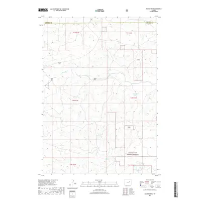
2017 Map of Macken Draw
USGS Topo · Published 2017About this map
Thunder Basin National Grassland dominates this portion of the Powder River Basin, where the high plains landscape is defined by a network of seasonal watercourses. The drainage of Antelope Creek and its tributary Macken Draw flow through the center of the sheet, carving paths through the dissected terrain. This area, spanning the boundary between Campbell and Converse counties, represents a quintessential Western ranching landscape where infrastructure is sparse and tied to the land's topography.
Find a feature on this map
19 named features on this map. Tap any name to fly to it.
Don’t see what you’re looking for? This feature index may not catch every label — zoom into the map to look around manually.
Map Details
Editions of this 2017 Macken Draw Map
This is the sole edition of this map. No revisions or reprints were ever made.
Other maps of this area

1954 · Pine Tree
USGS Topo · 1:24,000

1955 · Newcastle
USGS Topo · 1:250,000

1958 · Newcastle
USGS Topo · 1:250,000

1959 · Coal Draw
USGS Topo · 1:62,500

1960 · Ross
USGS Topo · 1:62,500

1960 · Turnercrest
USGS Topo · 1:62,500

1974 · Reno Junction
USGS Topo · 1:100,000

1979 · Bill
USGS Topo · 1:100,000

1984 · Turnercrest
USGS Topo · 1:24,000
1984 · Coal Draw North
USGS Topo · 1:24,000