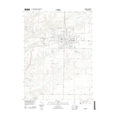
2015 Map of Macomb
USGS Topo · Published 2015About this map
The Western Illinois University campus dominates the landscape north of downtown Macomb, serving as a central hub for this portion of McDonough County. The city is surrounded by a dense network of burial grounds that offer significant value for genealogical research, including Oakwood Cem, Macomb Cem, and the Old Catholic Cemetery. These sites are clustered around residential developments like East Village and Georgetown, while peripheral areas such as Lamone Village mark the transition toward the agricultural landscape. The terrain is defined by the winding course of the East Fork La Moine River and its various tributaries, such as Killjordan Creek and Troublesome Creek. To the east, Smith Airport serves the local aviation needs, while smaller water bodies like Lake Michale and Cricketwood Green Lake provide local landmarks within the established street grid.
Find a feature on this map
130 named features on this map. Tap any name to fly to it.
Don’t see what you’re looking for? This feature index may not catch every label — zoom into the map to look around manually.
Map Details
Editions of this 2015 Macomb Map
This is the sole edition of this map. No revisions or reprints were ever made.
Other maps of this area

1912 · Macomb
USGS Topo · 1:62,500

1913 · Colchester
USGS Topo · 1:62,500

1914 · Macomb
USGS Topo · 1:62,500

1916 · Good Hope
USGS Topo · 1:62,500

1918 · La Harpe
USGS Topo · 1:62,500

1918 · Good Hope
USGS Topo · 1:62,500

1958 · Burlington
USGS Topo · 1:250,000

1961 · Burlington
USGS Topo · 1:250,000

1963 · Burlington
USGS Topo · 1:250,000
1974 · Doddsville
USGS Topo · 1:24,000