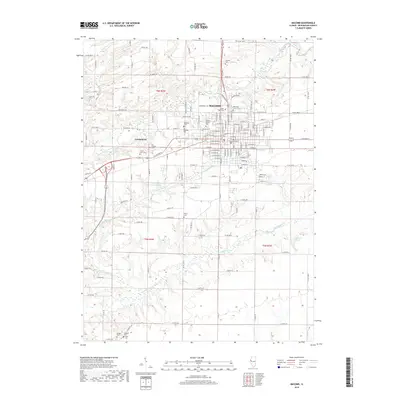
2018 Map of Macomb
USGS Topo · Published 2018About this map
Western Illinois Univ serves as a central anchor for the city of Macomb, surrounded by a dense network of residential streets and civic landmarks. This late-2010s survey details the urban layout of the county seat, where the commercial core is bounded by significant historical burial grounds including Old Macomb Cem and Oakwood Cem. Beyond the city limits, the landscape transitions into agricultural sections defined by the East Fork La Moine River and tributaries like Killjordan Creek and Troublesome Creek. The map provides excellent detail for genealogists, as it identifies numerous small family and community cemeteries such as Bailey Cem, Strader Cem, and Riden Cem scattered across the rural townships of t6n r3w and t5n r3w. These sites, often located at the intersections of county roads like Co RD 1150 N, offer a quiet record of the area's long-standing agrarian settlement patterns.
Find a feature on this map
151 named features on this map. Tap any name to fly to it.
Don’t see what you’re looking for? This feature index may not catch every label — zoom into the map to look around manually.
Map Details
Editions of this 2018 Macomb Map
This is the sole edition of this map. No revisions or reprints were ever made.
Other maps of this area

1912 · Macomb
USGS Topo · 1:62,500

1913 · Colchester
USGS Topo · 1:62,500

1914 · Macomb
USGS Topo · 1:62,500

1916 · Good Hope
USGS Topo · 1:62,500

1918 · La Harpe
USGS Topo · 1:62,500

1918 · Good Hope
USGS Topo · 1:62,500

1958 · Burlington
USGS Topo · 1:250,000

1961 · Burlington
USGS Topo · 1:250,000

1963 · Burlington
USGS Topo · 1:250,000
1974 · Doddsville
USGS Topo · 1:24,000