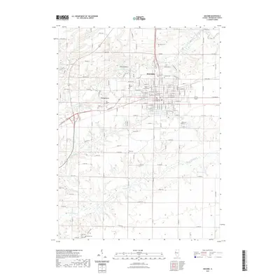
2021 Map of Macomb
USGS Topo · Published 2021About this map
Macomb and its surroundings in the early 2020s are defined by the convergence of institutional, civic, and natural features. The sprawling campus of Western Illinois University occupies the northwestern portion of the city, while the McDonough County Courthouse anchors the central downtown grid. The landscape is deeply carved by the East Fork La Moine River and its tributaries, including Killjordan Cr and Troublesome Cr, which create complex drainage patterns south of the primary settlement. A high density of burial sites across the quadrangle, such as Old Macomb Cem and Forest Lawn Cem, offers significant research value for those tracing the development of the community. Beyond the city limits, the settlement of Georgetown and the area of Wigwam Hollow highlight the residential expansion into the surrounding township lands.
Find a feature on this map
134 named features on this map. Tap any name to fly to it.
Don’t see what you’re looking for? This feature index may not catch every label — zoom into the map to look around manually.
Map Details
Editions of this 2021 Macomb Map
This is the sole edition of this map. No revisions or reprints were ever made.
Other maps of this area

1912 · Macomb
USGS Topo · 1:62,500

1913 · Colchester
USGS Topo · 1:62,500

1914 · Macomb
USGS Topo · 1:62,500

1916 · Good Hope
USGS Topo · 1:62,500

1918 · La Harpe
USGS Topo · 1:62,500

1918 · Good Hope
USGS Topo · 1:62,500

1958 · Burlington
USGS Topo · 1:250,000

1961 · Burlington
USGS Topo · 1:250,000

1963 · Burlington
USGS Topo · 1:250,000
1974 · Doddsville
USGS Topo · 1:24,000