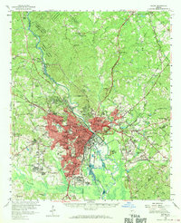
1956 Map of Macon
USGS Topo · Published 1970About this map
The Ocmulgee River carves a path through this mid-century landscape, anchoring a region where industrial activity and educational institutions define the urban core. The city of Macon is shown in considerable detail, noting critical civic infrastructure from the Court House and City Hall to the Georgia Academy for the Blind. To the south and east, the landscape transitions into heavy industry, marked by numerous strip mines, gravel pits, and brick kilns, particularly around Terra Cotta and Stratton.
Find a feature on this map
122 named features on this map. Tap any name to fly to it.
Don’t see what you’re looking for? This feature index may not catch every label — zoom into the map to look around manually.
Map Details
Editions of this 1956 Macon Map
3 editions found
Other maps of this area

1951 · Forsyth
USGS Topo · 1:62,500

1953 · Athens
USGS Topo · 1:250,000

1956 · Fort Valley
USGS Topo · 1:62,500

1956 · Bolingbroke
USGS Topo · 1:62,500

1956 · Gordon
USGS Topo · 1:62,500

1956 · Warner Robins
USGS Topo · 1:62,500

1956 · Jeffersonville
USGS Topo · 1:62,500

1956 · Macon West
USGS Topo · 1:24,000

1956 · Macon East
USGS Topo · 1:24,000

1956 · Macon
USGS Topo · 1:62,500