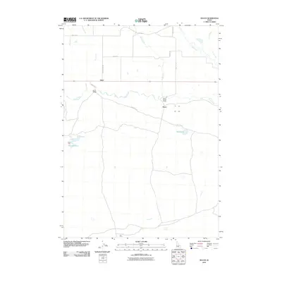
2010 Map of Macon
USGS Topo · Published 2010About this map
Camas Creek flows through the heart of this landscape, a region defined by its wide open high-desert flats and agricultural roots. The settlement of Macon and the nearby Blaine serve as the primary landmarks in this 2010 survey, connected by the historical Macon Flat Rd. Evidence of the area's pastoral and ranching legacy is found in names like the Macon Sheep Bridge and Pole Corral, while Princess Mine Rd suggests the proximity of earlier prospecting efforts. Water management is critical in this environment, as shown by Kelly Dam and its associated Kelly Reservoir, which alongside Macon Lake and the intermittent Lava Creek, illustrate the complex hydrology required to sustain this Idaho ranching country.
Find a feature on this map
24 named features on this map. Tap any name to fly to it.
Don’t see what you’re looking for? This feature index may not catch every label — zoom into the map to look around manually.
Map Details
Editions of this 2010 Macon Map
This is the sole edition of this map. No revisions or reprints were ever made.
Other maps of this area

1955 · Hailey
USGS Topo · 1:250,000

1957 · Thorn Creek
USGS Topo · 1:62,500

1957 · Bellevue
USGS Topo · 1:62,500

1957 · Blaine
USGS Topo · 1:62,500

1959 · Hailey
USGS Topo · 1:250,000

1962 · Hailey
USGS Topo · 1:250,000

1979 · Summit Reservoir
USGS Topo · 1:24,000
1986 · Thorn Creek Reservoir
USGS Topo · 1:24,000
1986 · Cannonball Mountain
USGS Topo · 1:24,000
1986 · Beaver Creek
USGS Topo · 1:24,000