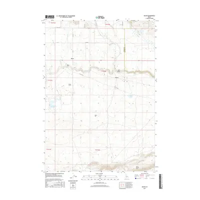
2017 Map of Macon
USGS Topo · Published 2017About this map
Camas Prairie defines the high-altitude landscape of this Idaho quadrangle, where the tiny settlements of Blaine and Macon sit near the winding course of Camas Creek. This 2017 survey details a landscape where livestock and water management take precedence over urban development. The topography shifts from the level expanses of Macon Flat to the rising elevations of the Mount Bennett Hills in the south. Connectivity in this area is marked by utilitarian crossings like the Blaine Bridge and the Macon Sheep Bridge, the latter highlighting the region's enduring sheep ranching heritage. Local water sources including Kelly Reservoir, Macon Lake, and the small Chicken Spring provide essential points of reference across the high desert terrain. Notable roads such as Lanman Rd and Macon Flat Rd trace old section lines, connecting remote homesteads and grazing lands along the Camas Co Blaine Co Line Rd.
Find a feature on this map
27 named features on this map. Tap any name to fly to it.
Don’t see what you’re looking for? This feature index may not catch every label — zoom into the map to look around manually.
Map Details
Editions of this 2017 Macon Map
This is the sole edition of this map. No revisions or reprints were ever made.
Other maps of this area

1955 · Hailey
USGS Topo · 1:250,000

1957 · Thorn Creek
USGS Topo · 1:62,500

1957 · Bellevue
USGS Topo · 1:62,500

1957 · Blaine
USGS Topo · 1:62,500

1959 · Hailey
USGS Topo · 1:250,000

1962 · Hailey
USGS Topo · 1:250,000

1979 · Summit Reservoir
USGS Topo · 1:24,000
1986 · Thorn Creek Reservoir
USGS Topo · 1:24,000
1986 · Cannonball Mountain
USGS Topo · 1:24,000
1986 · Beaver Creek
USGS Topo · 1:24,000