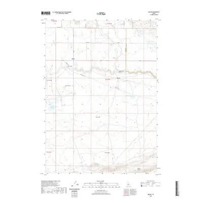
2020 Map of Macon
USGS Topo · Published 2020About this map
Camas Prairie provides the geographic foundation for this high-desert region in Blaine and Camas counties, where the high-altitude agricultural landscape meets the southern Mount Bennett Hills. This 2020 survey documents the rural character of the settlements at Macon and Blaine, which are situated along the winding course of Camas Creek. The map shows a transition from the level terrain of Macon Flat to the more complex water systems including Kelly Reservoir, Macon Lake, and several small tributaries like Fricke Cr and Willow Creek. Transport patterns are defined by the Macon Flat Rd and the significant river crossings at the Blaine Bridge and the Macon-Sheep Bridge. These crossings and the irrigation features like Chicken Spring highlight the historical reliance on water management in this high-plains environment.
Find a feature on this map
30 named features on this map. Tap any name to fly to it.
Don’t see what you’re looking for? This feature index may not catch every label — zoom into the map to look around manually.
Map Details
Editions of this 2020 Macon Map
This is the sole edition of this map. No revisions or reprints were ever made.
Other maps of this area

1955 · Hailey
USGS Topo · 1:250,000

1957 · Thorn Creek
USGS Topo · 1:62,500

1957 · Bellevue
USGS Topo · 1:62,500

1957 · Blaine
USGS Topo · 1:62,500

1959 · Hailey
USGS Topo · 1:250,000

1962 · Hailey
USGS Topo · 1:250,000

1979 · Summit Reservoir
USGS Topo · 1:24,000
1986 · Thorn Creek Reservoir
USGS Topo · 1:24,000
1986 · Cannonball Mountain
USGS Topo · 1:24,000
1986 · Beaver Creek
USGS Topo · 1:24,000