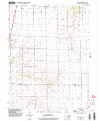
1998 Map of Macon East
USGS Topo · Published 2003About this map
Macon serves as the primary focal point in this Central Illinois landscape, situated at the intersection of a well-defined grid of section lines and transport corridors. The terrain is defined by the drainage systems of Sand Creek, Finley Creek, and the Willow Branch as they wind through the townships of South Wheatland and South Macon. The presence of Long Grove Cemetery and Sanner Chapel suggests long-established community roots in the rural areas outside of the main town center.
Find a feature on this map
24 named features on this map. Tap any name to fly to it.
Don’t see what you’re looking for? This feature index may not catch every label — zoom into the map to look around manually.
Map Details
Editions of this 1998 Macon East Map
This is the sole edition of this map. No revisions or reprints were ever made.
Other maps of this area

1929 · Decatur
USGS Topo · 1:62,500

1933 · Decatur
USGS Topo · 1:62,500

1949 · Dalton City
USGS Topo · 1:62,500

1952 · Assumption
USGS Topo · 1:62,500

1954 · Niantic
USGS Topo · 1:62,500

1958 · Decatur
USGS Topo · 1:250,000

1961 · Decatur
USGS Topo · 1:250,000

1967 · Long Creek
USGS Topo · 1:24,000

1967 · Decatur
USGS Topo · 1:24,000

1982 · Harristown
USGS Topo · 1:24,000