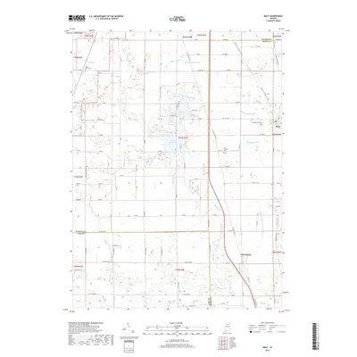
2019 Map of Macy
USGS Topo · Published 2019About this map
Nyona Lake and South Mud Lake define the central landscape of this Indiana interior region where the borders of Fulton, Miami, and Cass counties converge. The town of Macy serves as a local hub near the eastern edge, connected to surrounding farmsteads by a grid of numbered roads such as W 1300 N and W 1600 N. The drainage patterns here are heavily managed through an extensive network of man-made waterways including Fouts Ditch, Zanger Ditch, and Rannels Ditch, which channel water toward larger systems like Mud Cr. To the south, Perrysburg sits along S Old US Hwy 31, reflecting a quiet settlement pattern that has persisted for generations. Genealogists can find several small burial sites preserved in the landscape, such as Five Corners Cem and Plainview Cem near the town center.
Find a feature on this map
88 named features on this map. Tap any name to fly to it.
Don’t see what you’re looking for? This feature index may not catch every label — zoom into the map to look around manually.
Map Details
Editions of this 2019 Macy Map
This is the sole edition of this map. No revisions or reprints were ever made.
Other maps of this area

1951 · Peru
USGS Topo · 1:24,000

1951 · Twelve Mile
USGS Topo · 1:24,000

1953 · Chicago
USGS Topo · 1:250,000

1953 · Danville
USGS Topo · 1:250,000

1955 · Danville
USGS Topo · 1:250,000

1955 · Logansport
USGS Topo · 1:24,000

1956 · Danville
USGS Topo · 1:250,000

1957 · Chicago
USGS Topo · 1:250,000
1960 · Peru
USGS Topo · 1:24,000

1960 · Fulton
USGS Topo · 1:24,000