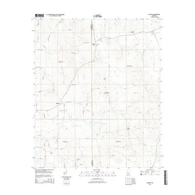
2015 Map of Madden
USGS Topo · Published 2015About this map
Leake and Neshoba counties are bisected by this rural survey, capturing a landscape of family-named roads and scattered communities. Small settlements like Madden and Dowdville serve as local anchors for a network of farm-to-market routes, including Dr Brantley Rd and Thomas Rd. The terrain is defined by a dense drainage system of creeks such as Standing Pine Cr and Luneluah Cr, which wind through the township boundaries of t10n r9e and t10n r10e. For genealogists, the map is a vital resource for locating rural landmarks and family burial sites, documenting Laurel Hill Cem, Carolina Cem, and Mount Bethany Cem. The density of named local roads, from Stribling Rd to Curley Peoples Rd, indicates the enduring residential patterns of this agricultural region in the early 21st century.
Find a feature on this map
78 named features on this map. Tap any name to fly to it.
Don’t see what you’re looking for? This feature index may not catch every label — zoom into the map to look around manually.
Map Details
Editions of this 2015 Madden Map
This is the sole edition of this map. No revisions or reprints were ever made.
Other maps of this area

1953 · Meridian
USGS Topo · 1:250,000

1957 · Meridian
USGS Topo · 1:250,000

1962 · Edinburg
USGS Topo · 1:62,500

1965 · Meridian
USGS Topo · 1:250,000

1972 · Pearl River
USGS Topo · 1:24,000

1972 · McAfee
USGS Topo · 1:24,000

1972 · Madden
USGS Topo · 1:24,000
1972 · Sebastopol
USGS Topo · 1:24,000
1972 · McDonald
USGS Topo · 1:24,000
1972 · Union West
USGS Topo · 1:24,000