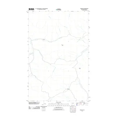
2011 Map of Maddux
USGS Topo · Published 2011About this map
Maddux serves as the primary point of settlement in this northern Montana landscape, situated near the headwaters of the North Fork Cow Creek. The terrain is defined by significant drainage networks and prominent high points like Murphy Butte and Bentel Divide. Local transit relies on corridors such as Hungry Hollow Rd, which follows the path of Battle Creek. One of the most significant landmarks for local history and genealogy is the Hungry Hollow Cemetery, located north of the divide. The map also traces the complex upper reaches of Clear Creek, including its east and west forks, showing a rural environment where water sources and topographic barriers dictate the placement of roads and homesteads.
Find a feature on this map
16 named features on this map. Tap any name to fly to it.
Don’t see what you’re looking for? This feature index may not catch every label — zoom into the map to look around manually.
Map Details
Editions of this 2011 Maddux Map
This is the sole edition of this map. No revisions or reprints were ever made.
Other maps of this area

1953 · Havre
USGS Topo · 1:250,000

1956 · Maddux
USGS Topo · 1:62,500

1956 · Lloyd
USGS Topo · 1:62,500

1957 · Havre
USGS Topo · 1:250,000

1958 · Havre
USGS Topo · 1:250,000

1959 · Warrick
USGS Topo · 1:62,500

1959 · Shambo
USGS Topo · 1:62,500

1984 · Big John Butte
USGS Topo · 1:24,000
1984 · Shambo SE
USGS Topo · 1:24,000
1984 · Warrick
USGS Topo · 1:24,000