1929 Map of Madison
USGS Topo · Published 1960About this map
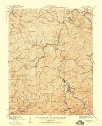
Madison and the neighboring settlement of Danville serve as the central hubs of this 1929 culture revision, situated at the confluence of the Little Coal River and Pond Fork. The landscape is defined by its dense network of hollows and ridges, such as Brushy Knob and Workman Knob, where life centered around dozens of small, local schoolhouses. Names like Fowler Sch, Slabtown Sch, and Grassy Fork Sch reveal the decentralized nature of these coal and timber communities before mid-century consolidation. The infrastructure of the Chesapeake and Ohio railroad, featuring the Pinnacle Tunnel and Blue Ton Tunnel, illustrates the critical transportation corridor carving through the terrain to connect towns like Julian and Uneeda to the broader regional economy. The map also captures numerous family-named landmarks like Lory and Breece, providing a rich resource for genealogical research in Boone and Lincoln counties.
Find a feature on this map
161 named features on this map. Tap any name to fly to it.
Don’t see what you’re looking for? This feature index may not catch every label — zoom into the map to look around manually.
Map Details
Editions of this 1929 Madison Map
This is the sole edition of this map. No revisions or reprints were ever made.
Other maps of this area

1887 · Warfield
USGS Topo · 1:125,000

1891 · Oceana
USGS Topo · 1:125,000

1891 · Warfield
USGS Topo · 1:125,000

1892 · Huntington
USGS Topo · 1:125,000

1893 · Oceana
USGS Topo · 1:125,000

1898 · Huntington
USGS Topo · 1:125,000

1898 · Oceana
USGS Topo · 1:125,000

1899 · Charleston
USGS Topo · 1:125,000

1902 · Milton
USGS Topo · 1:62,500

1902 · Midkiff
USGS Topo · 1:62,500