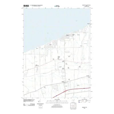
2010 Map of Madison
USGS Topo · Published 2010About this map
Lake Erie defines the northern boundary of this Lake County landscape, where the seasonal character of Madison-on-the-Lake and Madison Beach meets the inland agricultural and residential roots of Madison and Unionville. The terrain is marked by a series of glacial ridges, including North Ridge, which dictate the east-west orientation of major thoroughfares like Middle Ridge Rd. The winding path of Arcola Creek cuts through the center of the sheet, flowing toward the lake past several established burial grounds. For genealogists, the map is particularly detailed regarding local interments, showing the Old Unionville Cemetery, Fairview Cemetery, and Middle Ridge Cemetery. Small community clusters like Redbird, James Place, and Genung Corners provide a look at the suburban and rural development patterns of the early twenty-first century near the Madison Post Office.
Find a feature on this map
49 named features on this map. Tap any name to fly to it.
Don’t see what you’re looking for? This feature index may not catch every label — zoom into the map to look around manually.
Map Details
Editions of this 2010 Madison Map
This is the sole edition of this map. No revisions or reprints were ever made.
Other maps of this area

1904 · Chardon
USGS Topo · 1:62,500

1905 · Ashtabula
USGS Topo · 1:62,500

1905 · Perry
USGS Topo · 1:62,500

1905 · Jefferson
USGS Topo · 1:62,500

1906 · Chardon
USGS Topo · 1:62,500

1907 · Jefferson
USGS Topo · 1:62,500

1950 · Cleveland
USGS Topo · 1:250,000

1956 · Cleveland
USGS Topo · 1:250,000

1959 · East Trumbull
USGS Topo · 1:24,000
1960 · Painesville
USGS Topo · 1:24,000