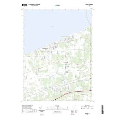
2023 Map of Madison
USGS Topo · Published 2023About this map
Lake Erie defines the northern reaches of this Lake County landscape, where coastal communities like Madison-on-the-Lake and Driftwood meet the shoreline. Moving inland, the terrain transitions into a dense network of local roads and historic ridge lines that historically dictated the settlement patterns of North Madison and Madison. This area is particularly rich in genealogical data, featuring an unusually high concentration of burial grounds such as North Ridge Cem, Middle Ridge Cem, and South Ridge Cem, which track the area's development from the lakefront to the interior. The presence of Woodworth Airport and the winding course of Arcola Creek further illustrate the mix of aviation history and natural drainage that shaped the township. Along the eastern boundary, the map clearly delineates the border between Lake County and Ashtabula County, marking a significant political and historical divide for local researchers.
Find a feature on this map
107 named features on this map. Tap any name to fly to it.
Don’t see what you’re looking for? This feature index may not catch every label — zoom into the map to look around manually.
Map Details
Editions of this 2023 Madison Map
This is the sole edition of this map. No revisions or reprints were ever made.
Other maps of this area

1904 · Chardon
USGS Topo · 1:62,500

1905 · Ashtabula
USGS Topo · 1:62,500

1905 · Perry
USGS Topo · 1:62,500

1905 · Jefferson
USGS Topo · 1:62,500

1906 · Chardon
USGS Topo · 1:62,500

1907 · Jefferson
USGS Topo · 1:62,500

1950 · Cleveland
USGS Topo · 1:250,000

1956 · Cleveland
USGS Topo · 1:250,000

1959 · East Trumbull
USGS Topo · 1:24,000
1960 · Painesville
USGS Topo · 1:24,000