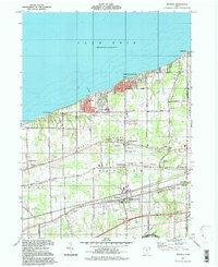
1994 Map of Madison
USGS Topo · Published 1997About this map
Lake Erie defines the northern reaches of this Ohio shoreline, where the community of Madison-on-the-Lake sits amidst a landscape of recreational sites and residential pockets like Redbird and Driftwood. The terrain is characterized by the parallel elevations of North Ridge and South Ridge, which historically dictated the path of regional travel and settlement. This 1990s-era documentation shows a mix of established rural infrastructure and modern amenities, including the Madison Memorial High Sch and a Drive-in Theater near Arcola Creek.
Find a feature on this map
51 named features on this map. Tap any name to fly to it.
Don’t see what you’re looking for? This feature index may not catch every label — zoom into the map to look around manually.
Map Details
Editions of this 1994 Madison Map
This is the sole edition of this map. No revisions or reprints were ever made.
Other maps of this area

1904 · Chardon
USGS Topo · 1:62,500

1905 · Ashtabula
USGS Topo · 1:62,500

1905 · Perry
USGS Topo · 1:62,500

1905 · Jefferson
USGS Topo · 1:62,500

1906 · Chardon
USGS Topo · 1:62,500

1907 · Jefferson
USGS Topo · 1:62,500

1950 · Cleveland
USGS Topo · 1:250,000

1956 · Cleveland
USGS Topo · 1:250,000

1959 · East Trumbull
USGS Topo · 1:24,000
1960 · Painesville
USGS Topo · 1:24,000