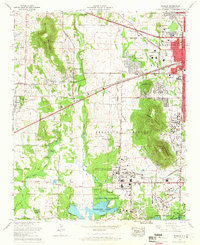
1964 Map of Madison
USGS Topo · Published 1966About this map
The Marshall Space Flight Center and the extensive Redstone Arsenal dominate this 1964 landscape, capturing the rapid mid-century expansion of northern Alabama's aerospace and military infrastructure. While the city of Huntsville presses westward with developments like Sherwood Park and the University of Alabama Huntsville Center, the map preserves older rural markers including the Royal Cem and Moore Cem. The geography is defined by a series of prominent elevations like Rainbow Mountain and Madkin Mountain, which overlook the industrial and scientific corridors. To the south, the terrain transitions into the wetlands of the Wheeler National Wildlife Refuge along the shores of Wheeler Lake, where Indian Creek and Barren Fork Creek drain into the Tennessee River system, contrasting the high-tech military installations with protected natural bottomlands.
Find a feature on this map
59 named features on this map. Tap any name to fly to it.
Don’t see what you’re looking for? This feature index may not catch every label — zoom into the map to look around manually.
Map Details
Editions of this 1964 Madison Map
This is the sole edition of this map. No revisions or reprints were ever made.
Other maps of this area

1888 · Huntsville
USGS Topo · 1:125,000

1892 · Huntsville
USGS Topo · 1:125,000

1936 · Jeff
USGS Topo · 1:24,000

1936 · Capshaw
USGS Topo · 1:24,000
1936 · Triana
USGS Topo · 1:24,000

1936 · Madison
USGS Topo · 1:24,000

1936 · Meridianville
USGS Topo · 1:24,000

1936 · Mason Ridge
USGS Topo · 1:24,000

1936 · Greenbrier
USGS Topo · 1:24,000

1936 · Farley
USGS Topo · 1:24,000