Loading...
Loading map...1914 Map of Madrid
USGS Topo · Published 1914About this map
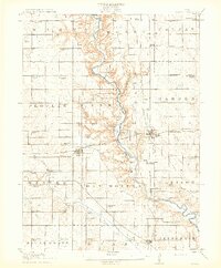
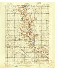
The Des Moines River carves a deep, winding valley through the center of this landscape, flanked by a dense network of early 20th-century rural schools and growing rail towns. Madrid and Woodward stand as primary hubs, connected by the Chicago Milwaukee and St Paul railroad, while the Inter-Urban RR cuts south through Moran and Granger. The river crossing is marked by significant engineering of the era, including the Elk Shoal Bridge and the Sixteen to One Bridge.
Find a feature on this map
86 named features on this map. Tap any name to fly to it.
Don’t see what you’re looking for? This feature index may not catch every label — zoom into the map to look around manually.
Map Details
Date Portrayed1914
Date Published1914
PublisherU.S. Geological Survey
Map TypeTopographic
Scale1:62,500
Physical Dimensions16.35 x 19.8 inches
Editions of this 1914 Madrid Map
3 editions found

Historical Maps of Johnston Through Time

Featured Locations
Source Details
SourceU.S. Geological Survey
CopyrightPublic Domain