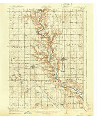
1914 Map of Madrid
USGS Topo · Published 1940About this map
The Des Moines River winds through the heart of this central Iowa landscape, carving a deep valley through the townships of Marcy, Worth, and Cass. Surveyed just before the first World War, the map reveals a dense network of rural infrastructure, particularly its rural school system. Nearly every section of land is served by a local institution, from the Centennial School in the northwest to Garden Prairie School in the east. The rail corridors of the Chicago Milwaukee and St. Paul and the Inter-Urban line define the local economy, connecting agricultural hubs like Woodward, Madrid, and Luther. The terrain transitions from the high, flat prairies of Peoples township into the intricate drainage basins of Beaver Creek and Caton Creek, illustrating the complex topography that governed early settlement patterns and road placements.
Find a feature on this map
80 named features on this map. Tap any name to fly to it.
Don’t see what you’re looking for? This feature index may not catch every label — zoom into the map to look around manually.
Map Details
Editions of this 1914 Madrid Map
3 editions found
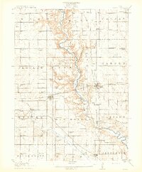
Other maps of this area

1905 · Des Moines
USGS Topo · 1:62,500

1907 · Des Moines
USGS Topo · 1:62,500

1908 · Waukee
USGS Topo · 1:62,500

1911 · Madrid
USGS Topo · 1:62,500

1911 · Slater
USGS Topo · 1:62,500

1912 · Ames
USGS Topo · 1:62,500

1913 · Slater
USGS Topo · 1:62,500

1914 · Madrid
USGS Topo · 1:62,500

1914 · Ames
USGS Topo · 1:62,500

1916 · Boone
USGS Topo · 1:62,500