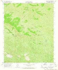
1964 Map of Madulce Peak
USGS Topo · Published 1965About this map
Madulce Peak 6536 anchors this high-elevation section of the Los Padres National Forest in the mid-1960s. The landscape is defined by an intricate network of drainage systems including Santa Barbara Canyon, Mono Canyon, and Alamar Canyon. Human presence is marked primarily by backcountry infrastructure, with the Madulce Guard Station serving as a central point of reference for the surrounding trails and campgrounds. A system of routes, including the Sierra Madre Mts Road and several Jeep Trails, provides limited access to remote points like Loma Pelona 4457 and Don Victor Valley. The distribution of sites like the Bill Faris Campground, Dutch Oven Campground, and Pine Canyon Campground illustrates the forest's development for recreation and fire management during this era, long before modern digital mapping documented these interior canyons.
Find a feature on this map
27 named features on this map. Tap any name to fly to it.
Don’t see what you’re looking for? This feature index may not catch every label — zoom into the map to look around manually.
Map Details
Editions of this 1964 Madulce Peak Map
2 editions found
Other maps of this area

1902 · Santa Ynez
USGS Topo · 1:125,000

1903 · Mt. Pinos
USGS Topo · 1:125,000

1905 · Santa Ynez
USGS Topo · 1:125,000

1942 · Little Pine Mountain
USGS Topo · 1:24,000

1943 · Big Pine Mountain
USGS Topo · 1:31,680

1943 · Rancho Nuevo Creek
USGS Topo · 1:24,000

1943 · Old Man Mountain
USGS Topo · 1:24,000

1943 · Cuyama Peak
USGS Topo · 1:24,000

1943 · Hildreth Peak
USGS Topo · 1:24,000
1943 · Fox Mountain
USGS Topo · 1:24,000