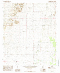
1985 Map of Magdalena Gap
USGS Topo · Published 1985About this map
Magdalena Gap defines the high-relief northwest corner of this Dona Ana County landscape, where the terrain falls away into a broad, arid basin dominated by drainage systems and livestock infrastructure. In this 1985 survey, the economy of the land is visible through a scattered network of water catchment features, such as Georgie Tank, Blackburn Tank, and Coldiron Tank. These tanks, along with ephemeral waterways like Mason Draw and Candler Draw, illustrate the vital management of water in the New Mexico desert.
Find a feature on this map
15 named features on this map. Tap any name to fly to it.
Don’t see what you’re looking for? This feature index may not catch every label — zoom into the map to look around manually.
Map Details
Editions of this 1985 Magdalena Gap Map
This is the sole edition of this map. No revisions or reprints were ever made.
Other maps of this area

1941 · Aden
USGS Topo · 1:62,500

1943 · Aden
USGS Topo · 1:62,500

1943 · Corralitos Ranch
USGS Topo · 1:62,500

1955 · Las Cruces
USGS Topo · 1:250,000

1958 · Las Cruces
USGS Topo · 1:250,000

1972 · Cambray
USGS Topo · 1:24,000

1972 · Good Sight Peak NE
USGS Topo · 1:24,000

1972 · Lazy E Ranch
USGS Topo · 1:24,000
1982 · Deming
USGS Topo · 1:100,000
1985 · Mount Aden
USGS Topo · 1:24,000