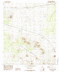
1985 Map of Mount Aden
USGS Topo · Published 1985About this map
The West Potrillo Mountains dominate this southwestern landscape, showing the arid terrain of New Mexico during the mid-1980s. This Department of the Interior survey illustrates a region defined by its volcanic geology and sparse water resources, centered on the small settlement of Aden and the nearby peak of Mount Aden. The presence of numerous dry basins, such as Mauries Lake, Muzzle Lake, and Daley Lake, underscores the seasonal nature of the local environment. Industrial and transport activity is marked by the Southern Pacific railroad line, which is supported by infrastructure like the RR Tank. Evidence of resource extraction is visible through several Gravel Pit and Borrow Pit locations near the main transit corridors, including the Trans Line and an extensive Pipeline. This document serves as a detailed record of the Aden Hills and the expansive White Flat, capturing the intersection of desert landforms and twentieth-century infrastructure.
Find a feature on this map
16 named features on this map. Tap any name to fly to it.
Don’t see what you’re looking for? This feature index may not catch every label — zoom into the map to look around manually.
Map Details
Editions of this 1985 Mount Aden Map
This is the sole edition of this map. No revisions or reprints were ever made.
Other maps of this area

1941 · Aden
USGS Topo · 1:62,500

1943 · Aden
USGS Topo · 1:62,500

1943 · Corralitos Ranch
USGS Topo · 1:62,500

1955 · Las Cruces
USGS Topo · 1:250,000

1958 · Las Cruces
USGS Topo · 1:250,000

1972 · Cambray
USGS Topo · 1:24,000
1972 · X-7 Ranch
USGS Topo · 1:24,000

1972 · Lazy E Ranch
USGS Topo · 1:24,000
1982 · Deming
USGS Topo · 1:100,000
1985 · Magdalena Gap
USGS Topo · 1:24,000