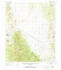
1959 Map of Magdalena
USGS Topo · Published 1970About this map
The mining-driven geography of the Magdalena Mountains defines this 1959 survey of Socorro County. At the heart of the district lies the settlement of Magdalena, serving as a terminal point for the Aitchison Topeka and Santa Fe railroad line. To the southeast, the mountain slopes are deeply marked by the region's industrial heritage, featuring a concentration of shafts and tunnels including the Graphic Mine, the Hardscrabble Mine, and the Paschal Shaft near the settlement of Kelly.
Find a feature on this map
58 named features on this map. Tap any name to fly to it.
Don’t see what you’re looking for? This feature index may not catch every label — zoom into the map to look around manually.
Map Details
Editions of this 1959 Magdalena Map
2 editions found

Other maps of this area

1906 · Socorro
USGS Topo · 1:62,500

1916 · La Joya
USGS Topo · 1:125,000

1948 · San Antonio
USGS Topo · 1:62,500

1952 · San Anacia
USGS Topo · 1:24,000

1954 · Tularosa
USGS Topo · 1:250,000

1954 · Socorro
USGS Topo · 1:250,000

1958 · Socorro
USGS Topo · 1:250,000

1958 · Tularosa
USGS Topo · 1:250,000

1959 · Socorro
USGS Topo · 1:24,000

1959 · Lemitar
USGS Topo · 1:24,000