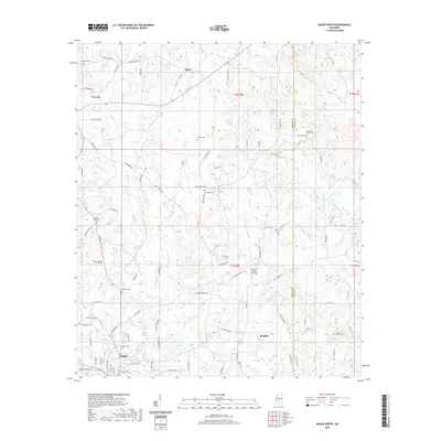
2020 Map of Magee North
USGS Topo · Published 2020About this map
Magee serves as the primary hub in this portion of Simpson County, where the grid of residential streets like Raleigh Dr meets the outlying rural landscape. The topography is defined by the branching networks of Okatoma Cr and its many tributaries, including Dry Creek and Little Hitchapaloo Cr. This landscape is heavily marked by its local history, evidenced by a high density of rural burial grounds such as Pine Grove Baptist Church Cem and Shady Grove Cem. Small clusters of activity at Upton and Maddox reflect the dispersed settlement pattern characteristic of the region. The map provides a detailed view of the local road system, from established routes like Old Magee Rd to numerous family-named paths like W C Allen Rd and J N Kennedy Rd, which connect the various creek valleys and church-centered communities.
Find a feature on this map
90 named features on this map. Tap any name to fly to it.
Don’t see what you’re looking for? This feature index may not catch every label — zoom into the map to look around manually.
Map Details
Editions of this 2020 Magee North Map
This is the sole edition of this map. No revisions or reprints were ever made.
Other maps of this area

1935 · White Oak
USGS Topo · 1:24,000

1953 · Hattiesburg
USGS Topo · 1:250,000

1953 · Meridian
USGS Topo · 1:250,000

1957 · Meridian
USGS Topo · 1:250,000

1958 · Hattiesburg
USGS Topo · 1:250,000

1965 · Meridian
USGS Topo · 1:250,000

1968 · White Oak
USGS Topo · 1:24,000
1968 · Puckett
USGS Topo · 1:24,000

1968 · Raleigh
USGS Topo · 1:24,000

1970 · Mendenhall East
USGS Topo · 1:24,000