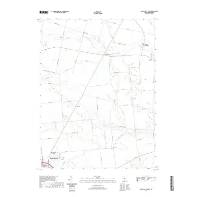
2019 Map of Magnetic Springs
USGS Topo · Published 2019About this map
Magnetic Springs and Pharisburg anchor this rural landscape in Union County, where agricultural fields are defined by a complex network of waterways and county roads. The drainage pattern of the region is traced by Bokes Creek, Blues Creek, and Mill Creek, alongside smaller tributaries like Grassy Run and Smith Run. In the southern portion of the sheet, the northern edge of Marysville appears, featuring residential developments near Woodview Park and Fleetwood Park. For genealogists, the map is particularly rich in cemetery locations, documenting smaller family or community burial grounds such as Maskill Cem, Scott Cem, Hopewell Cem, and Maple Dell Cem. The terrain is also marked by distinct features like the Twin Lakes and the man-made Infirmary Ditch, illustrating how the land has been managed for local utility and recreation in the early twenty-first century.
Find a feature on this map
66 named features on this map. Tap any name to fly to it.
Don’t see what you’re looking for? This feature index may not catch every label — zoom into the map to look around manually.
Map Details
Editions of this 2019 Magnetic Springs Map
This is the sole edition of this map. No revisions or reprints were ever made.
Other maps of this area

1901 · Dublin
USGS Topo · 1:62,500

1903 · Dublin
USGS Topo · 1:62,500

1913 · Richwood
USGS Topo · 1:62,500

1915 · Richwood
USGS Topo · 1:62,500

1916 · Milford Center
USGS Topo · 1:62,500

1924 · Delaware
USGS Topo · 1:62,500

1925 · Delaware
USGS Topo · 1:62,500

1944 · Richwood
USGS Topo · 1:62,500

1944 · Milford Center
USGS Topo · 1:62,500

1944 · Delaware
USGS Topo · 1:62,500