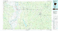
1986 Map of Magnolia
USGS Topo · Published 1986About this map
Red River and the Sulphur River dominate the western reach of this survey, creating a complex network of bayous and wetlands that includes the Sulphur River State Wildlife Management Area. This mid-1980s data shows the persistent importance of the petroleum industry throughout the region, with numerous Oil and Gas Fields scattered between Magnolia and Lewisville. The St Louis Southwestern Railroad serves as a primary transit corridor, linking settlements like Stamps and Stephens.
Find a feature on this map
96 named features on this map. Tap any name to fly to it.
Don’t see what you’re looking for? This feature index may not catch every label — zoom into the map to look around manually.
Map Details
Editions of this 1986 Magnolia Map
2 editions found
Other maps of this area

1901 · Gurdon
USGS Topo · 1:125,000

1903 · Camden
USGS Topo · 1:125,000

1907 · Atlanta
USGS Topo · 1:62,500

1909 · Texarkana
USGS Topo · 1:62,500

1910 · Atlanta
USGS Topo · 1:62,500

1922 · Sarepta
USGS Topo · 1:62,500

1924 · Sarepta
USGS Topo · 1:62,500

1932 · Hosston NW
USGS Topo · 1:31,680

1932 · Hosston NE
USGS Topo · 1:31,680

1944 · Kildare
USGS Topo · 1:62,500