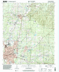
2000 Map of Magnolia
USGS Topo · Published 2002About this map
Magnolia serves as the focal point of this South Arkansas survey, appearing at a time of significant institutional and industrial established presence. The campus of Southern State College dominates the northern portion of the city, while the local infrastructure includes Columbia High School and several municipal parks like Eastside Park. The surrounding landscape is defined by the Magnolia Oil and Gas Field, indicating the region's long-standing reliance on resource extraction, further evidenced by numerous Gas Wells and a network of pipelines crossing the terrain.
Find a feature on this map
66 named features on this map. Tap any name to fly to it.
Don’t see what you’re looking for? This feature index may not catch every label — zoom into the map to look around manually.
Map Details
Editions of this 2000 Magnolia Map
This is the sole edition of this map. No revisions or reprints were ever made.
Other maps of this area

1953 · El Dorado
USGS Topo · 1:250,000

1957 · El Dorado
USGS Topo · 1:250,000

1958 · El Dorado
USGS Topo · 1:250,000

1960 · El Dorado
USGS Topo · 1:250,000

1960 · Macedonia
USGS Topo · 1:24,000

1966 · Village
USGS Topo · 1:24,000

1966 · Calhoun
USGS Topo · 1:24,000

1966 · Spotville
USGS Topo · 1:24,000

1968 · Lamartine
USGS Topo · 1:24,000

1968 · Waldo
USGS Topo · 1:24,000