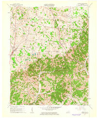
1961 Map of Magnolia
USGS Topo · Published 1963About this map
Magnolia and Mount Sherman anchor this rural landscape in LaRue County during the early 1960s, a region defined by agricultural plots, scattered family cemeteries, and the industrial footprint of the Magnolia Gas Storage Field. Numerous country churches serve as local landmarks, including Benningfield Chapel, Mt Moriah Ch, and Mt Sherman Ch. The terrain is deeply carved by the drainage systems of Lynn Camp Creek and Walters Creek, while the southern edge of the map features the historic site of Aetna Furnace. These topographical details reveal a community balance between traditional land use and mid-century energy infrastructure, evidenced by the Radio Tower W L I P Pumping Sta and various gas wells. Genealogists may find particular interest in the specific locations of the Russell Cem and Holly Grove Cem situated amongst the rolling Kentucky hills.
Find a feature on this map
32 named features on this map. Tap any name to fly to it.
Don’t see what you’re looking for? This feature index may not catch every label — zoom into the map to look around manually.
Map Details
Editions of this 1961 Magnolia Map
2 editions found
Other maps of this area

1934 · Munfordville
USGS Topo · 1:48,000

1935 · Elizabethtown
USGS Topo · 1:48,000

1937 · Munfordville
USGS Topo · 1:62,500

1938 · Elizabethtown
USGS Topo · 1:62,500

1949 · Tonieville
USGS Topo · 1:24,000
1949 · Elizabethtown
USGS Topo · 1:62,500

1953 · Howardstown
USGS Topo · 1:24,000

1953 · Hudgins
USGS Topo · 1:24,000

1953 · Hibernia
USGS Topo · 1:24,000

1953 · Summersville
USGS Topo · 1:24,000