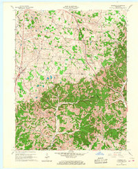
1961 Map of Magnolia
USGS Topo · Published 1968About this map
Magnolia serves as the primary hub for this rural Kentucky landscape during the early 1960s, situated near the border of Larue, Hart, and Green Counties. The area is characterized by a network of small agricultural settlements and religious centers, including Mount Sherman and Gatton. A significant industrial layer is present in the form of the Magnolia Gas Storage Field, which occupies a large portion of the southern terrain, accompanied by various Gas Wells and infrastructure.
Find a feature on this map
26 named features on this map. Tap any name to fly to it.
Don’t see what you’re looking for? This feature index may not catch every label — zoom into the map to look around manually.
Map Details
Editions of this 1961 Magnolia Map
2 editions found
Other maps of this area

1934 · Munfordville
USGS Topo · 1:48,000

1935 · Elizabethtown
USGS Topo · 1:48,000

1937 · Munfordville
USGS Topo · 1:62,500

1938 · Elizabethtown
USGS Topo · 1:62,500

1949 · Tonieville
USGS Topo · 1:24,000
1949 · Elizabethtown
USGS Topo · 1:62,500

1953 · Howardstown
USGS Topo · 1:24,000

1953 · Hudgins
USGS Topo · 1:24,000

1953 · Hibernia
USGS Topo · 1:24,000

1953 · Summersville
USGS Topo · 1:24,000