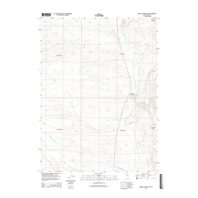
2014 Map of Mahala Creek East
USGS Topo · Published 2014About this map
The Valley of the North Fork serves as a central drainage corridor in this part of Elko County, where the N Fork Humboldt River flows through high desert terrain. To the northeast, the Bone Mountains rise above the basin, while the landscape to the west is deeply etched by a network of seasonal watercourses including Sheep Cr, Mahala Cr, and Gance Cr. Human presence is evidenced primarily by remote infrastructure such as Keddy Ranch Rd and Coal Mine Canyon Rd, which navigate the canyons and creek beds. Near the river, Warm Springs provides a localized hydrological point of interest. This 2014 survey captures the traditional ranching and open-range character of the region, illustrating how the topography of Middle Field Canyon and surrounding ridges dictates the path of travel and water management in this arid environment.
Find a feature on this map
19 named features on this map. Tap any name to fly to it.
Don’t see what you’re looking for? This feature index may not catch every label — zoom into the map to look around manually.
Map Details
Editions of this 2014 Mahala Creek East Map
This is the sole edition of this map. No revisions or reprints were ever made.
Other maps of this area

1955 · Wells
USGS Topo · 1:250,000

1958 · Wells
USGS Topo · 1:250,000

1961 · Wells
USGS Topo · 1:250,000

1971 · Mahala Creek West
USGS Topo · 1:24,000

1971 · Double Mtn
USGS Topo · 1:24,000
1971 · Coal Mine Basin
USGS Topo · 1:24,000

1971 · North Fork
USGS Topo · 1:24,000

1971 · California Mtn.
USGS Topo · 1:24,000
1971 · Wieland Flat
USGS Topo · 1:24,000
1971 · Reed Station
USGS Topo · 1:24,000