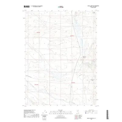
2018 Map of Mahala Creek East
USGS Topo · Published 2018About this map
N Fork Humboldt River carves through the central portion of this Elko County landscape, defining the wide Valley of the North Fork as it flows south. The terrain is characterized by the high elevations of the Bone Mountains in the northeast and the deep incision of Middle Field Canyon. This 2018 survey illustrates a high-desert drainage network where seasonal and perennial waters like Sheep Cr, Mahala Cr, and Gance Cr converge toward the river basin. Human presence is marked by primitive and ranching roads, including Keddy Ranch Rd and Coal Mine Rd, which provide access to this remote interior. Small geothermal features such as Warm Springs dot the eastern slopes, while the western portion of the quadrangle is accessed by the Natl Forest Develop Road 002 Rd.
Find a feature on this map
19 named features on this map. Tap any name to fly to it.
Don’t see what you’re looking for? This feature index may not catch every label — zoom into the map to look around manually.
Map Details
Editions of this 2018 Mahala Creek East Map
This is the sole edition of this map. No revisions or reprints were ever made.
Other maps of this area

1955 · Wells
USGS Topo · 1:250,000

1958 · Wells
USGS Topo · 1:250,000

1961 · Wells
USGS Topo · 1:250,000

1971 · Mahala Creek West
USGS Topo · 1:24,000

1971 · Double Mtn
USGS Topo · 1:24,000
1971 · Coal Mine Basin
USGS Topo · 1:24,000

1971 · North Fork
USGS Topo · 1:24,000

1971 · California Mtn.
USGS Topo · 1:24,000
1971 · Wieland Flat
USGS Topo · 1:24,000
1971 · Reed Station
USGS Topo · 1:24,000