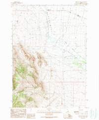
1989 Map of Mahogany Hill
USGS Topo · Published 1989About this map
Challis National Forest dominates the southwestern portion of this Idaho landscape, rising sharply toward the prominent summit of Mahogany Hill. The terrain transitions from these steep wooded slopes down into the broad Pahsimeroi Valley, where the Pahsimeroi River flows northward through a system of high-altitude ranching and range land. This 1980s provisional survey illustrates a complex hydrological network defined by numerous springs and seasonal drainages like Goldburg Creek and Big Creek, which feed into the main river channel. The border between Lemhi and Custer counties cuts through the northern section of the map, following a path across the valley floor. Evidence of local industry is sparse but present, noted by a Gravel Pit near the northern boundary, while rugged features like Monkey Gulch and the Canyon characterize the transition from the valley to the forest heights.
Find a feature on this map
13 named features on this map. Tap any name to fly to it.
Don’t see what you’re looking for? This feature index may not catch every label — zoom into the map to look around manually.
Map Details
Editions of this 1989 Mahogany Hill Map
This is the sole edition of this map. No revisions or reprints were ever made.
Other maps of this area

1935 · Borah Peak
USGS Topo · 1:125,000

1938 · Borah Peak
USGS Topo · 1:125,000

1955 · Dubois
USGS Topo · 1:250,000

1956 · Patterson
USGS Topo · 1:62,500

1956 · Donkey Hills
USGS Topo · 1:62,500

1956 · Doublespring
USGS Topo · 1:62,500

1956 · May
USGS Topo · 1:62,500

1958 · Dubois
USGS Topo · 1:250,000

1980 · Leadore
USGS Topo · 1:100,000
1989 · May
USGS Topo · 1:24,000