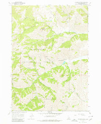
1967 Map of Mahoney Butte
USGS Topo · Published 1980About this map
Clarendon Hot Springs and a series of deep canyon drainages define this portion of the Sawtooth National Forest in the late 1960s. The landscape is heavily marked by its mineral history, with several notable extraction sites located in the high gulches, including the Red Cloud Mine and the Democrat Mine. A complex network of Pack Trails and Jeep Trails provides the primary access through the steep terrain, connecting various gulches with names that hint at prospector history such as Jolly Sailor Gulch, War Dance Gulch, and Bullion Gulch.
Find a feature on this map
37 named features on this map. Tap any name to fly to it.
Don’t see what you’re looking for? This feature index may not catch every label — zoom into the map to look around manually.
Map Details
Editions of this 1967 Mahoney Butte Map
3 editions found
Other maps of this area

1895 · Hailey
USGS Topo · 1:125,000

1897 · Hailey
USGS Topo · 1:125,000

1900 · Sawtooth
USGS Topo · 1:125,000

1955 · Hailey
USGS Topo · 1:250,000

1957 · Bellevue
USGS Topo · 1:62,500

1957 · Blaine
USGS Topo · 1:62,500

1957 · Bellevue
USGS Topo · 1:24,000

1959 · Hailey
USGS Topo · 1:250,000

1962 · Hailey
USGS Topo · 1:250,000

1967 · Mahoney Butte
USGS Topo · 1:24,000