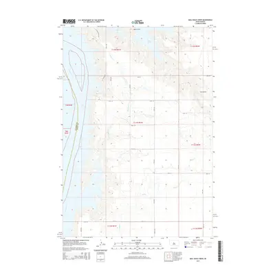
2015 Map of Mail Shack Creek
USGS Topo · Published 2015About this map
Lake Oahe and the massive Missouri River corridor dominate this portion of Central South Dakota, marking the boundary between Stanley and Sully counties. The landscape is characterized by the expansive waters created by the Oahe Dam, with deep inlets like Mail Shack Creek and Sully Creek reaching into the high plains. Rising above the eastern shoreline, the Sully Buttes serve as a prominent landmark in an area defined by a strict section-line road grid, including 184th Street and Pasque Avenue. The presence of the Little Bend Access Road and Bakers Gulch in the north suggests the continued importance of river access and topographical drainage patterns in this sparsely settled prairie environment.
Find a feature on this map
29 named features on this map. Tap any name to fly to it.
Don’t see what you’re looking for? This feature index may not catch every label — zoom into the map to look around manually.
Map Details
Editions of this 2015 Mail Shack Creek Map
This is the sole edition of this map. No revisions or reprints were ever made.
Other maps of this area

1954 · Pierre
USGS Topo · 1:250,000

1958 · Pierre
USGS Topo · 1:250,000

1965 · Artichoke Butte SW
USGS Topo · 1:24,000

1965 · Okobojo
USGS Topo · 1:24,000

1969 · No Heart Creek SE
USGS Topo · 1:24,000

1969 · No Heart Creek SW
USGS Topo · 1:24,000
1973 · Iron Post Buttes SE
USGS Topo · 1:24,000

1973 · Iron Post Buttes SW
USGS Topo · 1:24,000

1973 · Iron Post Buttes
USGS Topo · 1:24,000
1973 · Okobojo SW
USGS Topo · 1:24,000