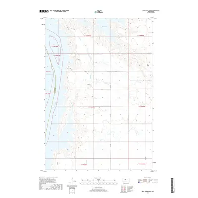
2017 Map of Mail Shack Creek
USGS Topo · Published 2017About this map
The Missouri River and the expansive waters of Lake Oahe dominate this landscape along the border of Stanley and Sully counties. This modern topographic study reveals the winding shoreline of the Missouri as it transitions into the reservoir system, fed by local tributaries such as Mail Shack Creek and Sully Creek. The terrain is defined by dramatic elevation changes, notably at Sully Buttes and the ravine of Bakers Gulch. While the area remains primarily open land, a network of rural roads such as Little Bend Drive and Pike Haven Place provides access to the waterfront, reflecting the contemporary balance of agricultural use and recreational proximity to the lake.
Find a feature on this map
26 named features on this map. Tap any name to fly to it.
Don’t see what you’re looking for? This feature index may not catch every label — zoom into the map to look around manually.
Map Details
Editions of this 2017 Mail Shack Creek Map
This is the sole edition of this map. No revisions or reprints were ever made.
Other maps of this area

1954 · Pierre
USGS Topo · 1:250,000

1958 · Pierre
USGS Topo · 1:250,000

1965 · Artichoke Butte SW
USGS Topo · 1:24,000

1965 · Okobojo
USGS Topo · 1:24,000

1969 · No Heart Creek SE
USGS Topo · 1:24,000

1969 · No Heart Creek SW
USGS Topo · 1:24,000
1973 · Iron Post Buttes SE
USGS Topo · 1:24,000

1973 · Iron Post Buttes SW
USGS Topo · 1:24,000

1973 · Iron Post Buttes
USGS Topo · 1:24,000
1973 · Okobojo SW
USGS Topo · 1:24,000