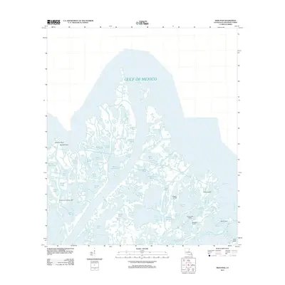
2012 Map of Main Pass
USGS Topo · Published 2012About this map
Romere Pass Seaplane Base anchors the western edge of this complex coastal landscape in Plaquemines Parish, where the Mississippi River delta meets the Gulf of Mexico. The area is a labyrinth of interconnected waterways and marshland, characterized by numerous named passes and bayous including Romere Pass, Octave Pass, and Battery Bayou. This 2012 survey illustrates the intricate island geography of the Louisiana coast, featuring landmasses such as Timber Island, Contrariete Island, and Scarabin Island. Small, isolated ponds like Snow Goose Bayou and Blue Goose Pond are scattered throughout the wetlands, reflecting a landscape shaped by shifting sediment and tides. For those studying the maritime infrastructure and coastal evolution of the region, the placement of these specific islands and aviation landmarks provides a precise baseline of the shoreline during the early 21st century.
Find a feature on this map
51 named features on this map. Tap any name to fly to it.
Don’t see what you’re looking for? This feature index may not catch every label — zoom into the map to look around manually.
Map Details
Editions of this 2012 Main Pass Map
This is the sole edition of this map. No revisions or reprints were ever made.
Other maps of this area

1893 · East Delta
USGS Topo · 1:62,500

1893 · Forts
USGS Topo · 1:62,500

1893 · West Delta
USGS Topo · 1:62,500

1935 · Taylor Pass
USGS Topo · 1:31,680

1947 · Pass A Loutre West
USGS Topo · 1:31,680

1947 · Venice
USGS Topo · 1:31,680

1947 · Main Pass
USGS Topo · 1:31,680

1947 · Pass A Loutre East
USGS Topo · 1:31,680

1948 · Forts
USGS Topo · 1:62,500

1949 · Cubits Gap
USGS Topo · 1:31,680