
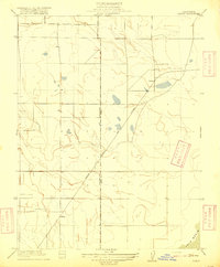
1916 Map of Maine Prairie
USGS Topo · Published 1916About this map
The northern delta country of Solano County reveals a landscape defined by seasonal wetlands and the burgeoning reach of the interurban rail system. The Oakland Antioch and Eastern railroad cuts a sharp diagonal across the prairie, reflecting the early 20th-century push for electric rail connectivity between the Bay Area and the Sacramento Valley. At the time of this 1906 survey, the settlement of Maine Prairie and the nearby Maine Prairie Sta served as vital hubs for the surrounding agricultural community, situated where the high ground met the complex waterway network of the delta.
Find a feature on this map
7 named features on this map. Tap any name to fly to it.
Don’t see what you’re looking for? This feature index may not catch every label — zoom into the map to look around manually.
Map Details
Editions of this 1916 Maine Prairie Map
This is the sole edition of this map. No revisions or reprints were ever made.
Other maps of this area

1907 · Antioch
USGS Topo · 1:62,500

1908 · Vacaville
USGS Topo · 1:62,500

1908 · Courtland
USGS Topo · 1:62,500

1908 · Antioch
USGS Topo · 1:62,500

1910 · Rio Vista
USGS Topo · 1:31,680

1916 · Dixon
USGS Topo · 1:31,680

1916 · Cache Slough
USGS Topo · 1:31,680
1916 · Saxon
USGS Topo · 1:31,680

1917 · Wolfskill
USGS Topo · 1:31,680

1917 · Elmira
USGS Topo · 1:31,680