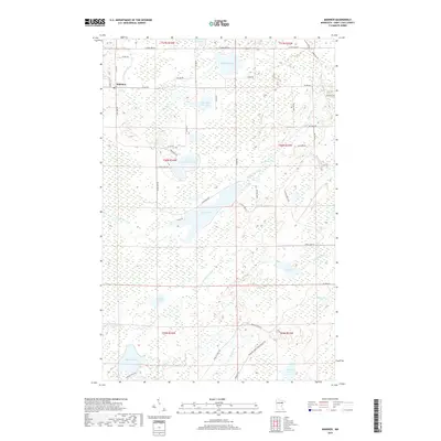
2019 Map of Makinen
USGS Topo · Published 2019About this map
Makinen sits in the northwest corner of this landscape, a region defined by a complex network of wetlands and interconnected water bodies in Saint Louis County. The Paleface River meanders across the southern sections, while the northern terrain is punctuated by Mud Hen Lake and Little Mud Hen Lake. The land is crisscrossed by a grid of local roads and forest management tracks, including Vermilion Trl and Washusk Forest Management Rd, reflecting the region's managed timber and natural resource character. This 2019 survey shows a landscape where water governs movement and settlement, from the larger basins of Long Lake and Wabuse Lake to the smaller, secluded Section Fourteen Lake and Dollar Lake. The abundance of creek systems, such as Water Hen Creek and Bobcat Creek, suggests a terrain that has remained largely defined by its natural hydrology well into the twenty-first century.
Find a feature on this map
53 named features on this map. Tap any name to fly to it.
Don’t see what you’re looking for? This feature index may not catch every label — zoom into the map to look around manually.
Map Details
Editions of this 2019 Makinen Map
This is the sole edition of this map. No revisions or reprints were ever made.
Other maps of this area

1951 · Palo
USGS Topo · 1:24,000

1951 · Gilbert
USGS Topo · 1:24,000

1951 · Central Lakes
USGS Topo · 1:24,000

1951 · Makinen
USGS Topo · 1:24,000

1954 · Hibbing
USGS Topo · 1:250,000

1956 · Cotton
USGS Topo · 1:24,000

1956 · Whiteface
USGS Topo · 1:24,000

1957 · Hibbing
USGS Topo · 1:250,000

1957 · Markham
USGS Topo · 1:62,500

1957 · Comstock Lake
USGS Topo · 1:24,000