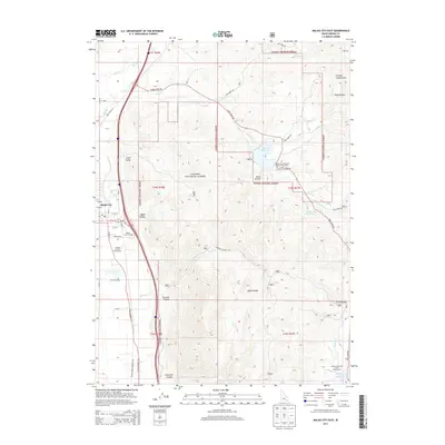
2013 Map of Malad City East
USGS Topo · Published 2013About this map
Malad City sits at the edge of the Malad Range, serving as the primary hub for this portion of southern Idaho. The layout of the town is anchored by the Oneida County Fairgrounds and the Malad City Cem, with residential streets reaching toward the foothills of the Caribou National Forest. Water management is a central theme of the landscape, seen in the series of impoundments that include Deep Cr Reservoir, Upper Deep Cr Reservoir, and the Weston Cr Reservoir further south. These reservoirs, alongside numerous named hollows like Chicken Coop Hollow and Susan Hollow, illustrate a landscape where mountain drainage is carefully captured for local use. The map also traces the transition from the valley floor at Little Valley into the steep breaks of Twomile Canyon and Fourmile Canyon, documenting the relationship between the settlement and its mountainous surroundings.
Find a feature on this map
47 named features on this map. Tap any name to fly to it.
Don’t see what you’re looking for? This feature index may not catch every label — zoom into the map to look around manually.
Map Details
Editions of this 2013 Malad City East Map
This is the sole edition of this map. No revisions or reprints were ever made.
Other maps of this area

1954 · Pocatello
USGS Topo · 1:250,000

1958 · Pocatello
USGS Topo · 1:250,000

1968 · Samaria
USGS Topo · 1:24,000

1968 · Malad Summit
USGS Topo · 1:24,000

1968 · Oxford
USGS Topo · 1:24,000

1968 · Malad City West
USGS Topo · 1:24,000

1968 · Malad City East
USGS Topo · 1:24,000
1968 · Henderson Creek
USGS Topo · 1:24,000

1968 · Clifton
USGS Topo · 1:24,000
1968 · Weston Canyon
USGS Topo · 1:24,000